Space Pictures / Venus (Update)Use the arrows above the picture for navigation and click the picture itself to see the 'Update' and 'Original' versions. |
|
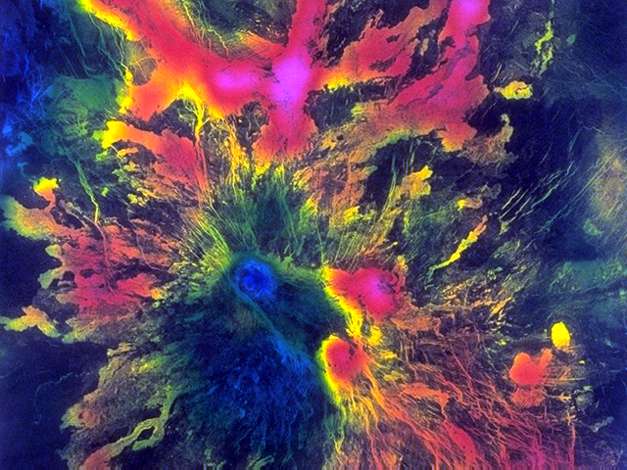
Title: Phoebe Regio, Venus Source: Magellan Information: This Magellan mosaic centered at 12.5 degrees south latitude, 261 degrees east longitude, shows an unnamed volcano that straddles a narrow, angular fracture system extending southeastward from Phoebe Regio, a highland tessera, or tile-appearing, region of Venus. The image, which shows an area approximately 587 kilometers (364 miles) on a side, is a synthetic aperture radar (SAR) backscatter image combined with a color radio-thermal emission (emissivity) image. The red corresponds to a high emissivity, blue to a low emissivity. The emissivity, which is a measure of the electrical properties of surface materials, is an important clue for understanding surface composition. While many Magellan images display just the radar backscatter in order to obtain information about the shape and roughness of features, there are other important data sets including the surface topography obtained from the Magellan altimeter and the emissivity. Information to derive emissivity is recorded when Magellan's radar antenna ceases to send signals to the surface and instead listens to the radio waves naturally emitted from the surface. This volcano exhibits what scientists have noted to be a widespread phenomenon on Venus -- the occurrence of lower emissivities at higher altitudes. The summit of the volcano, which is about 2 kilometers (1.2) miles in height, displays the lowest emissivity, while the emissivity becomes progressively greater toward the lower elevations. The presence of minerals such a pyrrohite or pyrite may explain the low emissivities in some cases because of their electrical properties and their stability at the temperatures and pressures found at high altitudes on Venus. This image was produced at the JPL Multimission Image Processing Laboratory. |
